How the Todas’ sacred grass was ‘rediscovered’

The Todas are a tiny tribal group living in the Nilgiri mountains in the Western Ghats of India. Traditionally, they relied on a special breed called Toda buffalo, who provided them with milk and butter. The preferred habitat of the buffalo is wetlands, originally abundant on the Nilgiri Plateau. The Todas derived their construction material from their immediate environment and the thatch for their temples is a wetland grass. Unfortunately, most of the native forests (locally called sholas) and grasslands, including the wetlands, have vanished under agriculture and plantations. Only the western side of the Nilgiri Plateau, under protection, still has wetlands which contains the Todas’ “sacred” grass.

Early 2000s, Tarun Chabbra, a retired dentist in Ooty, and a renowned specialist of the Toda culture, contacted me. The sacred grass was becoming rare, which created yet another stress for this tiny community. Tarun asked me to help understand why the grass was disappearing.

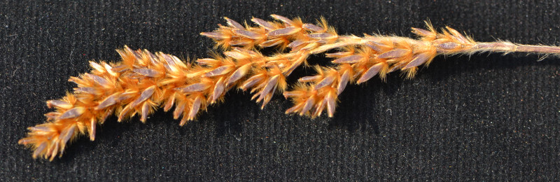
The grass is beautiful with soft velvety leaves and rufus inflorescences. It forms large tussocks with the roots submerged and the leaves almost always above water. Covered by this grass, the wetlands look slightly greyish. The small soft hair, being maybe an adaptation to the high UV intensity, is the cause of this effect.

The grass was introduced to me as Andropogon polypticus. The first thing to do was to confirm its identity. Since we were working with a competent botanist, D. Mohandass who was a research scholar at Pondicherry University and later worked for the Xishuangbanna Tropical Botanical Garden (XTBG), I relied on him to confirm the species’ name. Grasses are relatively difficult to identify as they require dissecting flowers that are one millimetre long, to describe the parts and understanding the structure of the inflorescence. To do so, it is best to have a good microscope, patience and stable hands.

I had asked Mohandass to provide me with the sketch of the flower parts that I could verify. Since he mostly worked with trees, he was not used to grasses and he kept on producing drawings that were not clear to me. After a few dedicated trials, I decided to ask the French Institute if I could use their microscope. The Director graciously accepted. I identified the grass as Eriochrysis rangacharii with the amazing book authored by Bor (1960). Since no one around us knew this species, I consulted the Red Data Book of Indian Plants by Nayar and Sastry (1987). There, we learnt that the species was “presumed extinct” because it had not been found for more than a century. With this surprising result, I checked again with Intkey (https://www.delta-intkey.com/grass/ident.htm), a digital key made especially for grasses, with the same result.

This caused problems. First, rediscovering a species is a surprise, and we could not take the risk of informing the public that we had “rediscovered” a species if it was good old A. polypticus. Second, if the species was so rare as to be missed by botanists for a century, then it might be in jeopardy, and serious effort might be necessary to preserve it. As I had interiorized that ecologists and particularly myself are poor botanists, I decided to ask a world-renowned grass specialist, Dr Cope of the British Museum, for verification. He generously looked at the grass and confirmed my identification. Following this, we wrote a small note to announce the rediscovery to botanists (Puyravaud et al. 2012).

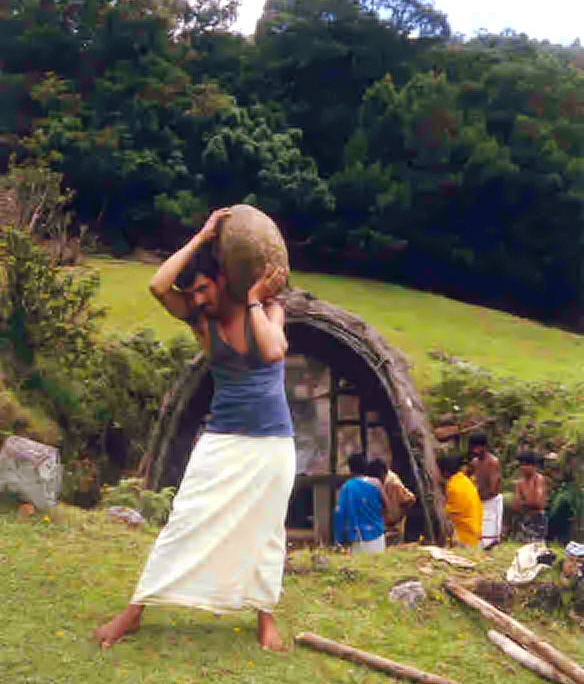
Toda temple with preparations for ceremony

We decided then to do a small-scale study on this species to assess factors that threaten its existence (Puyravaud et al. 2012). Dr. Mohandass again carried out a field assessment and found that overgrazing by cattle reduced its density in the wetlands. Cows, contrary to the Toda buffaloes, have narrow hoofs that compact the soil. A relatively large number of cows would destroy the soil by crushing it, therefore reducing its ability to hold water. Consequently, the dry soil would affect the survival of E. rangacharii.

Cattle had been introduced by tea plantations and the workers of the Tamil Nadu Electricity Board. It was accepted, even encouraged that people would herd cattle. Unfortunately, the local ecology is not adapted to cattle grazing, and the survival of E. rangacharii was threatened even in the most remote and protected parts of the Nilgiri. During an assessment by the Rainforest Alliance, we encouraged the management of the Korakundah Tea Estate to protect some wetlands. Mr. D. Hegde, then in charge of the estate, was convinced of the importance of protecting wetlands and agreed to spare a few wetlands within the estate. Apart from this conservation effort, we did not go much further because we rapidly realized that there was very little interest in endangered plant species from donor agencies and we could not continue to fund studies ourselves.

We heard afterwards that a few anthropologists insisted that A. polypticus was the grass preferred by the Todas. We knew that the Todas recognize E. rangacharii without its flowers because the velvety leaves are soft whatever the direction they are stroked. A. polypticus’ leaves, on the contrary, are soft in one direction only. Confusion therefore is unlikely. But is it possible that the Todas use both species? Or a mixture of wetland grasses with E. rangacharii dominating? These questions should be examined further by specialists. However, it is remarkable that the people who remained fully aware of the status of the species were the Todas. Without their cultural traditions, no one would have known of the slow disappearance of E. rangacharii.

The story does not end here. I read later that Blasco (1971) had mentioned this species. His book was written in French, this is why it escaped the review of Nayar and Sastry (1987). The ‘rediscovery’ was after all an overstatement. Still, E. rangacharii definitely has a precarious status because the condition of natural wetland habitat is dire. The best would be to preserve the remote wetlands as they are and let this beauty of nature enjoy the howling wind of the monsoon play with its hair in the grey solitude of the mountain.

Jean-Philippe Puyravaud, 31 July 2026.

References

Blasco, F. (1971). Montagnes du sud de l’Inde: Forêts, savanes, écologie. Institut français de Pondichéry.

Bor, N. (1960). The grasses of Burma, Ceylon, India and Pakistan. Pergamon Press.

Puyravaud, J. P., Mohandass, D., & Chhabra, T. (2003). A rediscovery of Eriochrysis rangacharri Fischer (Poaceae) in the Nilgiri Mountains of southern India. Candollea, 58, 97–100.

Puyravaud, J. P., Mohandass, D., & Davidar, P. (2012). Impact of human-related disturbance on Eriochrysis rangacharii Fischer, a rare keystone endemic grass (Nilgiris, southern India): A preliminary assessment. Tropical Ecology, 53(1), 25–32.

Acknowledgement

Priya Davidar reviewed this article.

About this post

This post was written without the use of AI.
Expert vs. calculated corridors

A map as a banner.

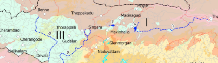
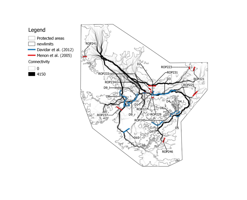
E.R.C. Davidar, the founder of the Sigur Nature Trust, undertook a study in the late 1970’s with the support of the Bombay Natural History Society on the elephant corridors of the Nilgiri (Davidar, 1981; see Davidar et al. 2012). He adopted an interesting approach: he assumed that elephants had circled the Nilgiri Mountains before the development of agriculture. He concluded that if we wanted to preserve elephant movement, then corridors should be organized with the objective of maintaining crucial passages that preserved historical patterns of displacement. Taking this as a guideline, he surveyed the Nilgiri on foot or on elephant back courtesy of the Tamil Nadu Forest Department and identified a few important corridors. Some were habitats in between villages, some had been encroached and needed to be restored, and some were critical habitats like the Sigur Plateau, that link the Eastern Ghats and the Western Ghats (Figure 1).

Map representing elephant corridors of the Sigur Region according to Davidar (1981).

Figure 1. Elephant corridors of the Sigur Region according to Davidar (1981).

In 2005, the Right of Passage (Menon et al. 2005) was published. It is a compendium of elephant corridors in India, but we could not make sense of the corridors occurring in our region. A little later, in 2010, the Tamil Nadu issued a notice to protect an elephant corridor starting from the Mudumalai Tiger Reserve to join the Sigur Reserved Forest. This project was challenged by the hospitality industry and affected persons who argued that the corridor identified by the Forest Department was not listed in the Right of Passage.

The issue was confusing. Who was right, who was wrong? In order to get some clarity, we embarked on the study described below. Our goal was to examine how computer simulation would depict corridors. Dr Sam Cushman, an eminent landscape ecologist was part of the effort.

A model of population connectivity is produced by calculating a resistance surface, then deciding rules for elephant movement and finally drawing elephant movement based on some algorithm. First, the landscape must be described by meaningful variables. For example, land use, slope and elevation are known to impact movement as elephants prefer not to go through large settlements nor climb steep slopes. The resistance surface is the merging of all relevant variables according to a selection process. Simulated elephants will have more or less difficulties to move from one place to another depending upon the value of the resistance surface. The simulated elephants will also obey certain rules. In our case, elephants were located at several thousand start locations and had each the same amount of energy to spend on meeting resistance from the landscape. With this energy, some elephants could travel far whenever the resistance surface was easy to cross. Other elephants got stuck where resistance was high, for example in human-dominated areas. The paths that required the least amount of energy between locations were retained. The superimposition of the thousands of elephant movements along their least-cost paths identified the main corridors.

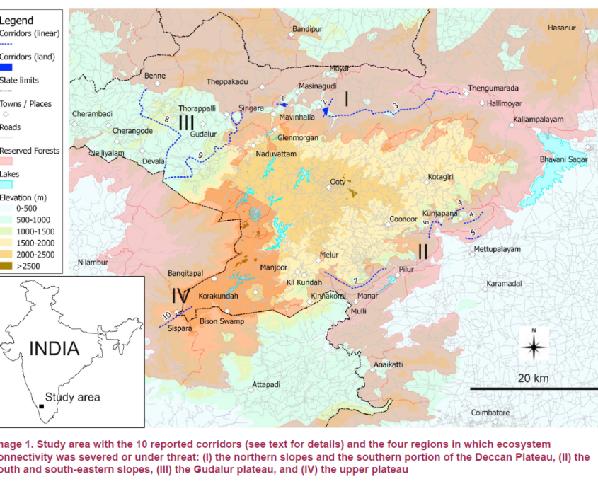
In our paper, “Predicting landscape connectivity for the Asian elephant in its largest remaining subpopulation” (Puyravaud et al. 2016), the connectivity map (Figure 2) was produced and compared with expert corridors.

Map of the elephant corridors in the Nilgiri Biosphere Reserve according to Puyravaud et al. (2016).

Figure 2. Elephant corridors in the Nilgiri Biosphere Reserve according to Puyravaud et al. (2016).

The first impression from this map is that the corridors network looks like the vascular system of an organism, with a few big corridors (‘the arteries’) linking many small corridors (‘the veins’). The model indicates that there are preferred routes even in protected areas.

Second, corridors cover the entire Nilgiri Biosphere Reserve. Many lie comfortably sheltered in the midst of a protected area. Others are threatened by human activities. These are the places that must be given the highest attention.

Third, the automatic calculation created a hierarchy of corridors. The ones that are long and darker coloured have tremendous importance for the species. Those that are lighter coloured and short end up at the reserves’ limits. Important corridors circle the Nilgiri as predicted by Davidar. Whenever the protected areas are large and suitable for the elephant, like in the Bandipur Tiger Reserve and Mudumalai Tiger Reserve, we observe a lot of corridors. When the protected areas are narrow and less suitable because of steep slopes, like in the southeast of the Nilgiri Biosphere Reserve, only the main corridors remain.

This map therefore differs from expert opinion as it shows that connectivity is not a local issue but a landscape issue. An elongated habitat is very much worth protecting whenever it is aligned with a corridor that begins in protected areas. There would be no point in protecting a passage perpendicular to elephant movement.

An additional difference is that experts tend to focus on problematic areas near villages. Automatic calculation shows that long and important corridors are within protected areas and when infrastructures such as roads are built, it affects elephant movement in a very severe way.

Further, expert corridors do not necessarily coincide with calculated corridors. There are several reasons for this. Experts do not position corridors as exactly as geographic information systems (GISs) do. Conservationists also focus on places they think should remain connected when they are under threat. The GIS did not follow the same logic in our study because we did not indicate which places might be under threat.

The lack of correspondence between the expert corridors and the calculated corridors is only apparent. There is much more agreement between automatic calculations and both expert teams than among Davidar (1981) and Menon et al. (2005). Calculated corridors consequently form a consensus that is better than expert opinion. Since calculations can always be improved with more knowledge and better techniques, the location of calculated corridors can only become more accurate.

The corridor map showed that the elephant corridors of the Sigur Region link two major biogeographic areas: the Western Ghats and the Eastern Ghats. The Sigur Region with its multiple villages clearly needs very careful management to prevent human activities from further blocking elephant passages.

It is obvious that the Right of Passage did not list “all” corridors and if a corridor does not appear in the Right of Passage, it does not mean it does not exist. Lastly, the notified corridor of the Tamil Nadu Forest Department overlaps with the main corridors of the Sigur Plateau.

In all, this work was useful to clarify the status of expert corridors and thereby can help to formulate better conservation measures overall.

Jean-Philippe Puyravaud, 18 July 2026.

References

Davidar, E. R. C. (1981). Investigation of the elephant migration paths in the Nilgiri Hills and inquiry into impediments to the free movements of elephants there and recommendations for the provision of corridors for their movement. Unpublished report, Bombay Natural History Society.

Davidar, E. R. C., Davidar, P., Davidar, P., & Puyravaud, J.-P. (2012). Elephant (Elephas maximus Linnaeus Proboscidea: Elephantidae) migration paths in the Nilgiri Hills, India in the late 1970s. Journal of Threatened Taxa, 4(14), 3284–3293.

Menon, V., Tiwari, V., Easa, S., & Sukumar, R. (2005). Right of Passage: Elephant Corridors of India. Wildlife Trust of India.

Puyravaud, J.-P., Cushman, S. A., Davidar, P., & Madappa, D. (2016). Predicting landscape connectivity for the Asian elephant in its largest remaining subpopulation. Animal Conservation, 20(3), 225–234. https://doi.org/10.1111/acv.12314

Acknowledgements

Priya Davidar reviewed this article.

About this post

This post was written without the use of AI.
Deciphering elephant corridor reports

If you are interested in conservation, you have heard the term “corridor”. There are several ways to define corridors. The simplest is to consider that a corridor is an elongated habitat linking two wildlife reserves.

Corridors are important because, in our world dominated by humans, protected areas are becoming increasingly isolated from each other. Wildlife movement is blocked, which results in genetic isolation and increased risk of local extinction. This is particularly the case for elephants who are large and vagile species. Without space, the species cannot survive. Consequently, elephant need to move from protected areas to other protected areas and places that connect these populations must be protected.

India is making major strides in ensuring that elephant populations are connected by enacting legislations. Several reports are dedicated to identifying and positioning elephant corridors to initiate protective measures. The Right of Passage (Menon et al., 2005; 2017) and Project Elephant, MoEF&CC, Government of India (2023) are such reports based on the expertise of numerous field personnel.

These reference documents are important to all stakeholders, including citizens, lawyers or decision makers because the management of elephant corridors involves protection of land. The number and location of corridors also matter to wildlife biologists who carry out research on this topic. Unfortunately, digitizing the corridors, creating a geographic information system (GIS) document, is challenging for plenty of reasons.

  • A huge impediment to the research community lies in the fact that none of the above-cited reports provide a vector map of their corridors. Probably dozens of students would like to represent some of these corridors on a map, but unfortunately, they will have to digitize them from the PDFs, which is error prone. There are not many reasons why the public should not have access to corridor vector layers. One reason may be that the authors are concerned that people would consider the corridor lines to be as tangible as the border between two states, a “thing” existing in the field and fixed once and for all. Obviously, this cannot be the meaning. Elephants do not follow a single path, the corridor line should be interpreted as an approximation, not unlike linear models that go through a cloud of points.
  • Often map legends are not legible. Not only are details difficult to interpret, but the map coordinates can be impossible to decipher. A map produced by a GIS is first exported to an image, second inserted into a text editor and third exported to a PDF. There are many reasons why the quality of the map should vary at each step. In spite of the numerous steps, the reader should be able to comprehend every detail of the maps. The quality control is neglected at the expense of comprehension.
  • Some maps lack context. Some corridors are large and the surrounding landscape will contain a village limit or a river. In this case, the corridor line will appear together with other symbols representing various landscape elements. This helps with the digitalization. Other corridors are small. Sometimes, the only landscape elements represented are portions of reserved forests. As no context is provided in these cases the reader cannot visualize the corridor’s location relative to other landscape elements, and it makes the digitalization challenging or impossible.
  • Often, no coordinate system is provided with the maps. The Right of Passage (Menon et al. 2017) produced maps without geographic references. This makes it very difficult to the reader to even figure where the region in question is located. Additionally, most maps are turned at 45 degrees, and the reader must keep on reorienting the document to examine the maps, which is extremely inconvenient on a computer.
  • Differing geocoordinates formats: authors sometimes use different format in the same document. In places geographic coordinates are decimal (ex: 11.899945˚ N) in other places they are in degrees, minutes and seconds (ex: 76˚ 2’ 0”). The lack of homogeneity is difficult to work out because it requires constant recalculations. Moreover, if you take the georeference and calculate its precision, you will be surprised to see that its precise to the millimetre, which does not correspond to reality.
  • Lack of valid spatial references: some maps have only one latitude and one longitude displayed without a scale. It is like having a single point on a cartesian reference system without the means to calculate distance to other points. Whether the map represents a small or a big area is for the reader to guess.
  • Incomplete legends: authors focused on representing forest divisions (often with serious alignment errors) and add other landscape elements symbols for convenience such a road or a railway line. Often, these elements do not appear in the legends, and their colour scheme is not much different from forest divisions limits. On the whole, this adds confusion to the map and unless the reader validates with a third document, the symbols can be confusing.

In conclusion, maps from these reports should be checked by a geographer. But if you want to digitize some elephant corridors, you will have to be patient and very careful to use each and every available detail on the maps. There will be misses as some corridors in the Western Ghats will be impossible to locate. Otherwise, you can request the authors for their vector files or ask them to put their results online.

Jean-Philippe Puyravaud, 21 June 2026

References

Menon, V., Tiwari, S., Ramkumar, K., Kyarong, S., Ganguly, U., & Sukumar, R. (2017). The right of passage—Elephant corridors of India (Second edition). Wildlife Trust of India.

Menon, V., Tiwari, V., Easa, S., & Sukumar, R. (2005). Right of Passage: Elephant Corridors of India. Wildlife Trust of India.

Project Elephant, MoEF&CC, Government of India. (2023). Elephant corridors of India 2023.

Acknowledgements

Priya Davidar reviewed this article.

About this post

This post was written without the use of AI.