Expert vs. calculated corridors
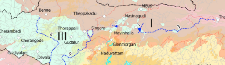
E.R.C. Davidar, the founder of the Sigur Nature Trust, undertook a study in the late 1970’s with the support of the Bombay Natural History Society on the elephant corridors of the Nilgiri (Davidar, 1981; see Davidar et al. 2012). He adopted an interesting approach: he assumed that elephants had circled the Nilgiri Mountains before the development of agriculture. He concluded that if we wanted to preserve elephant movement, then corridors should be organized with the objective of maintaining crucial passages that preserved historical patterns of displacement. Taking this as a guideline, he surveyed the Nilgiri on foot or on elephant back courtesy of the Tamil Nadu Forest Department and identified a few important corridors. Some were habitats in between villages, some had been encroached and needed to be restored, and some were critical habitats like the Sigur Plateau, that link the Eastern Ghats and the Western Ghats (Figure 1).
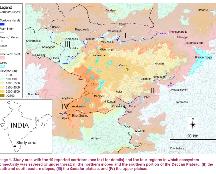
Figure 1. Elephant corridors of the Sigur Region according to Davidar (1981).
In 2005, the Right of Passage (Menon et al. 2005) was published. It is a compendium of elephant corridors in India, but we could not make sense of the corridors occurring in our region. A little later, in 2010, the Tamil Nadu issued a notice to protect an elephant corridor starting from the Mudumalai Tiger Reserve to join the Sigur Reserved Forest. This project was challenged by the hospitality industry and affected persons who argued that the corridor identified by the Forest Department was not listed in the Right of Passage.
The issue was confusing. Who was right, who was wrong? In order to get some clarity, we embarked on the study described below. Our goal was to examine how computer simulation would depict corridors. Dr Sam Cushman, an eminent landscape ecologist was part of the effort.
A model of population connectivity is produced by calculating a resistance surface, then deciding rules for elephant movement and finally drawing elephant movement based on some algorithm. First, the landscape must be described by meaningful variables. For example, land use, slope and elevation are known to impact movement as elephants prefer not to go through large settlements nor climb steep slopes. The resistance surface is the merging of all relevant variables according to a selection process. Simulated elephants will have more or less difficulties to move from one place to another depending upon the value of the resistance surface. The simulated elephants will also obey certain rules. In our case, elephants were located at several thousand start locations and had each the same amount of energy to spend on meeting resistance from the landscape. With this energy, some elephants could travel far whenever the resistance surface was easy to cross. Other elephants got stuck where resistance was high, for example in human-dominated areas. The paths that required the least amount of energy between locations were retained. The superimposition of the thousands of elephant movements along their least-cost paths identified the main corridors.
In our paper, “Predicting landscape connectivity for the Asian elephant in its largest remaining subpopulation” (Puyravaud et al. 2016), the connectivity map (Figure 2) was produced and compared with expert corridors.
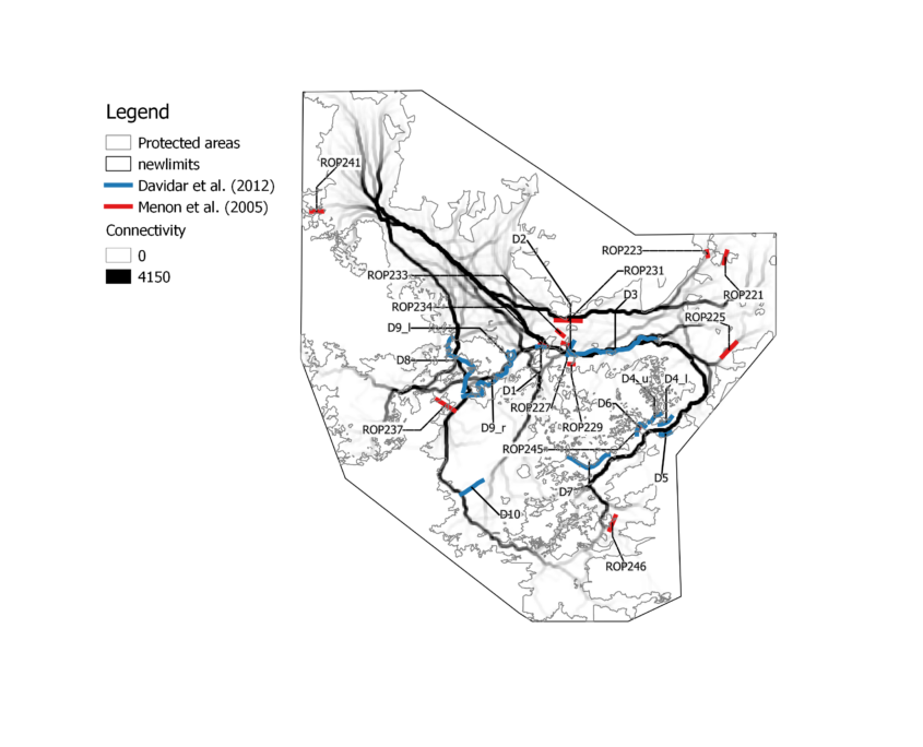
Figure 2. Elephant corridors in the Nilgiri Biosphere Reserve according to Puyravaud et al. (2016).
The first impression from this map is that the corridors network looks like the vascular system of an organism, with a few big corridors (‘the arteries’) linking many small corridors (‘the veins’). The model indicates that there are preferred routes even in protected areas.
Second, corridors cover the entire Nilgiri Biosphere Reserve. Many lie comfortably sheltered in the midst of a protected area. Others are threatened by human activities. These are the places that must be given the highest attention.
Third, the automatic calculation created a hierarchy of corridors. The ones that are long and darker coloured have tremendous importance for the species. Those that are lighter coloured and short end up at the reserves’ limits. Important corridors circle the Nilgiri as predicted by Davidar. Whenever the protected areas are large and suitable for the elephant, like in the Bandipur Tiger Reserve and Mudumalai Tiger Reserve, we observe a lot of corridors. When the protected areas are narrow and less suitable because of steep slopes, like in the southeast of the Nilgiri Biosphere Reserve, only the main corridors remain.
This map therefore differs from expert opinion as it shows that connectivity is not a local issue but a landscape issue. An elongated habitat is very much worth protecting whenever it is aligned with a corridor that begins in protected areas. There would be no point in protecting a passage perpendicular to elephant movement.
An additional difference is that experts tend to focus on problematic areas near villages. Automatic calculation shows that long and important corridors are within protected areas and when infrastructures such as roads are built, it affects elephant movement in a very severe way.
Further, expert corridors do not necessarily coincide with calculated corridors. There are several reasons for this. Experts do not position corridors as exactly as geographic information systems (GISs) do. Conservationists also focus on places they think should remain connected when they are under threat. The GIS did not follow the same logic in our study because we did not indicate which places might be under threat.
The lack of correspondence between the expert corridors and the calculated corridors is only apparent. There is much more agreement between automatic calculations and both expert teams than among Davidar (1981) and Menon et al. (2005). Calculated corridors consequently form a consensus that is better than expert opinion. Since calculations can always be improved with more knowledge and better techniques, the location of calculated corridors can only become more accurate.
The corridor map showed that the elephant corridors of the Sigur Region link two major biogeographic areas: the Western Ghats and the Eastern Ghats. The Sigur Region with its multiple villages clearly needs very careful management to prevent human activities from further blocking elephant passages.
It is obvious that the Right of Passage did not list “all” corridors and if a corridor does not appear in the Right of Passage, it does not mean it does not exist. Lastly, the notified corridor of the Tamil Nadu Forest Department overlaps with the main corridors of the Sigur Plateau.
In all, this work was useful to clarify the status of expert corridors and thereby can help to formulate better conservation measures overall.
Jean-Philippe Puyravaud, 18 July 2026.
References
Davidar, E. R. C. (1981). Investigation of the elephant migration paths in the Nilgiri Hills and inquiry into impediments to the free movements of elephants there and recommendations for the provision of corridors for their movement. Unpublished report, Bombay Natural History Society.
Davidar, E. R. C., Davidar, P., Davidar, P., & Puyravaud, J.-P. (2012). Elephant (Elephas maximus Linnaeus Proboscidea: Elephantidae) migration paths in the Nilgiri Hills, India in the late 1970s. Journal of Threatened Taxa, 4(14), 3284–3293.
Puyravaud, J.-P., Cushman, S. A., Davidar, P., & Madappa, D. (2016). Predicting landscape connectivity for the Asian elephant in its largest remaining subpopulation. Animal Conservation, 20(3), 225–234. https://doi.org/10.1111/acv.12314
Acknowledgements
Priya Davidar reviewed this article.
About this post
This post was written without the use of AI.