Deciphering elephant corridor reports
If you are interested in conservation, you have heard the term “corridor”. There are several ways to define corridors. The simplest is to consider that a corridor is an elongated habitat linking two wildlife reserves.
Corridors are important because, in our world dominated by humans, protected areas are becoming increasingly isolated from each other. Wildlife movement is blocked, which results in genetic isolation and increased risk of local extinction. This is particularly the case for elephants who are large and vagile species. Without space, the species cannot survive. Consequently, elephant need to move from protected areas to other protected areas and places that connect these populations must be protected.
India is making major strides in ensuring that elephant populations are connected by enacting legislations. Several reports are dedicated to identifying and positioning elephant corridors to initiate protective measures. The Right of Passage (Menon et al., 2005; 2017) and Project Elephant, MoEF&CC, Government of India, 2023) are such reports based on the expertise of numerous field personnel.
These reference documents are important to all stakeholders, including citizens, lawyers or decision makers because the management of elephant corridors involves protection of land. The number and location of corridors also matter to wildlife biologists who carry out research on this topic. Unfortunately, digitizing the corridors, creating a geographic information system (GIS) document, is challenging for plenty of reasons.
- A huge impediment to the research community lies in the fact that none of the above-cited reports provide a vector map of their corridors. Probably dozens of students would like to represent some of these corridors on a map, but unfortunately, they will have to digitize them from the PDFs, which is error prone. There are not many reasons why the public should not have access to corridor vector layers. One reason may be that the authors are concerned that people would consider the corridor lines to be as tangible as the border between two states, a “thing” existing in the field and fixed once and for all. Obviously, this cannot be the meaning. Elephants do not follow a single path, the corridor line should be interpreted as an approximation, not unlike linear models that go through a cloud of points.
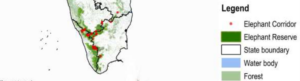
- Often map legends are not legible. Not only are details difficult to interpret, but the map coordinates can be impossible to decipher. A map produced by a GIS is first exported to an image, second inserted into a text editor and third exported to a PDF. There are many reasons why the quality of the map should vary at each step. In spite of the numerous steps, the reader should be able to comprehend every detail of the maps. The quality control is neglected at the expense of comprehension.
- Some maps lack context. Some corridors are large and the surrounding landscape will contain a village limit or a river. In this case, the corridor line will appear together with other symbols representing various landscape elements. This helps with the digitalization. Other corridors are small. Sometimes, the only landscape elements represented are portions of reserved forests. As no context is provided in these cases the reader cannot visualize the corridor’s location relative to other landscape elements, and it makes the digitalization challenging or impossible.
- Often, no coordinate system is provided with the maps. The Right of Passage (Menon et al. 2017) produced maps without geographic references. This makes it very difficult to the reader to even figure where the region in question is located. Additionally, most maps are turned at 45 degrees, and the reader must keep on reorienting the document to examine the maps, which is extremely inconvenient on a computer.
- Differing geocoordinates formats: authors sometimes use different format in the same document. In places geographic coordinates are decimal (ex: 11.899945˚ N) in other places they are in degrees, minutes and seconds (ex: 76˚ 2’ 0”). The lack of homogeneity is difficult to work out because it requires constant recalculations. Moreover, if you take the georeference and calculate its precision, you will be surprised to see that its precise to the millimetre, which does not correspond to reality.
- Lack of valid spatial references: some maps have only one latitude and one longitude displayed without a scale. It is like having a single point on a cartesian reference system without the means to calculate distance to other points. Whether the map represents a small or a big area is for the reader to guess.
- Incomplete legends: authors focused on representing forest divisions (often with serious alignment errors) and add other landscape elements symbols for convenience such a road or a railway line. Often, these elements do not appear in the legends, and their colour scheme is not much different from forest divisions limits. On the whole, this adds confusion to the map and unless the reader validates with a third document, the symbols can be confusing.
In conclusion, maps from these reports should be checked by a geographer. But if you want to digitize some elephant corridors, you will have to be patient and very careful to use each and every available detail on the maps. There will be misses as some corridors in the Western Ghats will be impossible to locate. Otherwise, you can request the authors for their vector files or ask them to put their results online.
Jean-Philippe Puyravaud, 21 June 2026
References
Menon, V., Tiwari, S., Ramkumar, K., Kyarong, S., Ganguly, U., & Sukumar, R. (2017). The right of passage—Elephant corridors of India (Second edition). Wildlife Trust of India.
Menon, V., Tiwari, V., Easa, S., & Sukumar, R. (2005). Right of Passage: Elephant Corridors of India. Wildlife Trust of India.
Project Elephant, MoEF&CC, Government of India. (2023). Elephant corridors of India 2023.
Acknowledgements
Priya Davidar reviewed this article.
About this post
This post was written without the use of AI.